- SMARTmuni
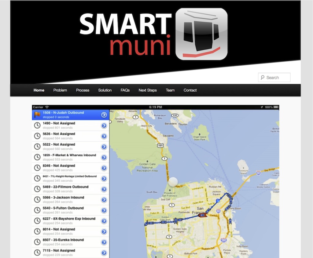
Developed with a team of other dedicated San Franciscans SMARTmuni uses a clean, location-aware interface to solve the complex data flow problems of running San Francisco’s transit system. It runs on top of the public NextBus database, accessing and compiling real time vehicle location data, connecting that information with trouble tickets. We’ve already had the opportunity to present the project to SFMTA Chief, Ed Reiskin, senior staff and operations managers, and at the 2011 Mayoral Candidate Debate.
Be sure to check out the demo video: SMARTmuni.org
- San Francisco Street Cleaning Website

The culmination of a lot of data massaging. Excited to finally throw out there a simple Google Maps interface with San Francisco Street Cleaning data.
Please report any issues by clicking on the post title and leaving a comment.
Visit the website: San Francisco Street Cleaning App
- CCKA: Areas of Special Biological Significance

While working at GreenInfo Network we developed a web map outlining Areas of Special Biological Significance for the California Coastkeeper Alliance. The multi-layered map shows Marine Protected Areas, state-wide Regional Water Board Boundaries, Critical Coastal Area Watersheds, and detail on the Areas of Special Biological Significance.
Visit the map here: http://www.cacoastkeeper.org/programs/healthy-marine-habitats/ASBS
- California Parcel Fragmentation

While working at GreenInfo Network we developed the WordPress website and maps illustrating the parcel fragmentation of land ownership in California. As one of the first projects of its kind, the California Parcel Fragmentation website sought to help interested parties understand the change from a native landscape to the fragmented ownership of today and the challenges that fragmentation presents. The degree of fragmentation of the private, rural land parcels is a critical factor for the future of ranching and farming, habitat conservation, fire prevention, delivery of services, water quality and much more. Deep zoom technology was used to enable users access to detail not visible on a printed map.
Visit the website: http://parcels.greeninfo.org/
- The City Project Map Portal

While working at GreenInfo Network we worked with The City Project to develop a navigation portal to access the county specific Green Access and Equity Reports. The City Project rolled the maps out in their blog.
- Winnipesaukee Gateway

While working at GreenInfo Network we assisted with the design, and led production, development, and content addition of this rich web 2.0 site to present the Lake Winnipesaukee Watershed Management Plan to the public. Rather than provide just a simple PDF report, we worked with the Lakes Region Planning Commission to develop an interactive website with dynamic mapping to more effectively present the management plan and provide an online medium for resources to protect the lake.
2011 NH Planning Association’s Project of the Year Award
Visit the website: http://winnipesaukeegateway.org/